

About this app
Multi-purpose mapping and surveying tool for both professional and personal use. The tool is valuable in several professional land-based surveying activities, including agriculture, forest management, infrastructure maintenance (e.g. roads and electrical networks), urban planning & real estate and emergencies mapping. It is also used for personal outdoor activities, such as hiking, running, walking, travelling and geocaching.
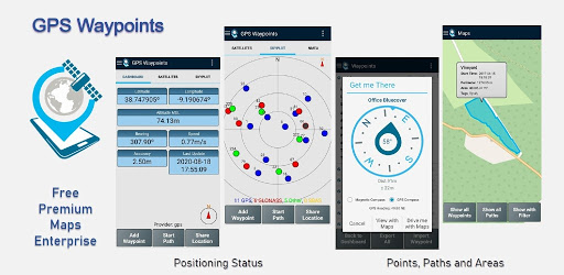
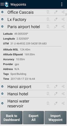
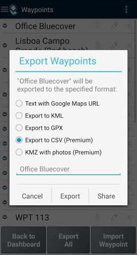
The application collects Points (such as points of interest) and Paths (sequence of points) to perform mapping and surveying activities. The Points, that are acquired with accuracy information, can be classified by the user with specific tags or characterized with photos. The Paths are created as a temporal sequence of newly acquired Points (e.g. to record a track) or alternatively with existing Points (e.g to create a route). Paths allows to measure distances and, if closed, forms Polygons that allows the determination of areas and perimeters. Both Points and Paths can be exported to a KML, GPX and CSV file and thus be processed externally with a geospatial tool.
The application uses the internal GPS receiver from the mobile device (typically with accuracies >3m) or, alternatively, allows professional users attaining better accuracies with a Bluetooth external GNSS receiver compatible with NMEA stream format (e.g. RTK receivers with centimeter level precision). See below some examples of the external receivers supported.
The application includes the following features:
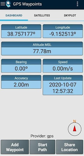
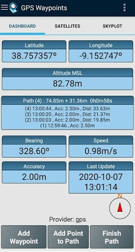
- Acquire current position with accuracy and navigation information;
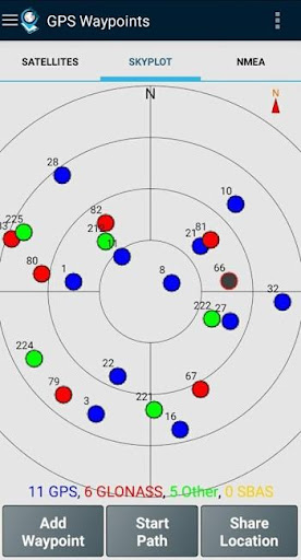
- Provide details of the active and visible satellites (GPS, GLONASS, GALILEO, BEIDOU and other);
- Create Points with accuracy information, classify them with Tags, attach photos and convert coordinates into a human-readable address (reverse geocoding);
- Import Points from geographic coordinates (lat, long) or by searching for a street address/point of interest (geocoding);
- Create Paths by acquiring sequences of points manually or automatically;
- Import Paths from existing Points;
- Create survey's themes with custom Tags for classifing Points and Paths
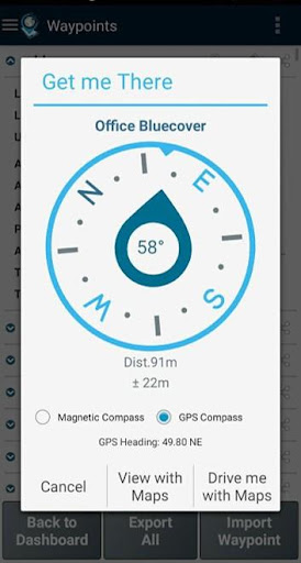
- Get directions and distances from current position to Points and Paths using a magnetic or gps compass;
- Export Points and Paths to KML and GPX file format;
- Share data with other applications (e.g. Dropbox/Google Drive);
- Configure positioning source for the internal receiver or using an external receiver.
The Premium subscription include the following professional features:
- Backup and restore user's data (it also allows transfer data from one handset to another);
- Export Waypoints and Paths to CSV file format;
- Export Waypoints with photos to KMZ file
- Import multiple Points and Paths from CSV and GPX files;
- Sort and filter Points and Paths by creation time, name and proximity;
- Satellite signal analysis and interferences detection.
The Maps feature is an extra paid funcionality that allows selecting and visualizing your Points, Paths and Polygons on Open Street Maps.
Additionally to the internal mobile receiver, the current version is known to work with the following external receivers: Bad Elf GNSS Surveyor; Garmin Glo; Navilock BT-821G; Qstarz BT-Q818XT; Trimple R1; ublox F9P.
If you successfully tested the application with another external receiver please provide us your feedback as a user or manufacturer in order to extend this list.
For further information check our site (https://www.bluecover.pt/gps-waypoints) and get the details of our complete offer:
- Free and Premium features (https://www.bluecover.pt/gps-waypoints/features)
- GISUY Receivers (https://www.bluecover.pt/gisuy-gnss-receiver/)
- Enterprise (https://www.bluecover.pt/gps-waypoints/enterprise-version/)
Downloads
1.2.3.4.5.6.7.8.9.0
LATEST
12/02/2024
Download
14.28 MB
1.2.3.4.5.6.7.8.9.0
LATEST12/02/2024
Supported Architectures
MD5 Checksum
81c3cb78b556e9ba519e29dc404448ae
Minimum SDK Version
23
Version Code
271
Upload Date
Dec 2, 2024, 4:43:07 AM
1.2.3.4.5.6.7.8.9.0
11/18/2024
Download
14.28 MB
1.2.3.4.5.6.7.8.9.0
11/18/2024
Supported Architectures
MD5 Checksum
4684ef4dbcb5e79445aab73e8b6860ed
Minimum SDK Version
23
Version Code
268
Upload Date
Nov 18, 2024, 8:15:55 PM
1.2.3.4.5.6.7.8.9.0
10/29/2024
Download
14.27 MB
1.2.3.4.5.6.7.8.9.0
10/29/2024
Supported Architectures
MD5 Checksum
b4d5f230dc2265baba865b75c51ef28d
Minimum SDK Version
23
Version Code
267
Upload Date
Oct 29, 2024, 6:10:29 PM
1.2.3.4.5.6.7.8.9.0
10/17/2024
Download
14.26 MB
1.2.3.4.5.6.7.8.9.0
10/17/2024
Supported Architectures
MD5 Checksum
34fed46f7b030595082c9da9c33edc29
Minimum SDK Version
23
Version Code
265
Upload Date
Oct 17, 2024, 9:18:57 AM
1.2.3.4.5.6.7.8.9.0
10/12/2024
Download
14.25 MB
1.2.3.4.5.6.7.8.9.0
10/12/2024
Supported Architectures
MD5 Checksum
fd31cf42326c2b2dc32acbd54885294d
Minimum SDK Version
23
Version Code
263
Upload Date
Oct 12, 2024, 12:49:56 PM
1.2.3.4.5.6.7.8.9.0
09/14/2024
Download
14.26 MB
1.2.3.4.5.6.7.8.9.0
09/14/2024
Supported Architectures
MD5 Checksum
c4d547d3b49c5f2b0698f348e8fceee7
Minimum SDK Version
23
Version Code
260
Upload Date
Sep 14, 2024, 1:11:11 PM
1.2.3.4.5.6.7.8.9.0
03/07/2024
Download
13.51 MB
1.2.3.4.5.6.7.8.9.0
03/07/2024
Supported Architectures
MD5 Checksum
15ae0d659712a2c2711221133018f2af
Minimum SDK Version
22
Version Code
246
Upload Date
Mar 7, 2024, 8:22:29 AM
1.2.3.4.5.6.7.8.9.0
03/21/2023
Download
12.01 MB
1.2.3.4.5.6.7.8.9.0
03/21/2023
Supported Architectures
MD5 Checksum
15ea8785be12b72d4fb42e96396927c4
Minimum SDK Version
22
Version Code
229
Upload Date
Mar 21, 2023, 5:41:57 AM
Similar Apps
Australian VPN Unlimited Proxy
5.0
everyone
Epson Spectrometer
5.0
everyone
Prospect Link
5.0
everyone
Nepal VPN - Get Nepal IP
5.0
everyone
Fast PDF Reader: Read PDF
5.0
everyone
Storage Manager Shortcut
5.0
everyone
Document Scanner - Scan to PDF
5.0
everyone
Master Management Connect
5.0
everyone
G-NetView Lite
5.0
everyone
Eco Weee
5.0
everyone