


About this app
The Autodesk® BIM 360™ Layout app for Android and BIM 360™ Document Management web service provide construction contractors the ability to connect the coordinated model to the field layout process, helping to increase job site productivity while improving the accuracy of staked or installed building components.
The app synchronizes with your BIM 360 account to download and upload project models with point location coordinate detail. Once paired with a robotic total station or GPS device, BIM 360 Layout on your Android™ tablet guides the user to the exact location of those points on the job site for field staking, verification and as-built collection.
NOTE: The BIM 360 Layout app is currently directly compatible with the following positioning hardware:
Topcon LN100W(BT model), LN-150, DS200, PS, GT Series; Sokkia SX, IX Series
Leica iCON 50/60/70/80 and iCT30; Viva/Nova TS/MS Series
GPS: NMEA-Supported External RTK GPS/GNSS Devices & GPS/GNSS Enabled (Internal) Tablets
NOTE: The BIM 360 Layout app requires a subscription to BIM 360 Coordinate Package.
To get a demo of BIM 360 Coordinate please visit: https://www.autodesk.com/bim-360/platform/bim-collaboration-software-constructability-review/
______________________
Share and Layout
◆ Share and layout points from within the BIM 360 Layout app with Revit, AutoCAD (including verticals), Navisworks, IFC Models and more
◆ Models and point data can be downloaded for offline use in the field. Ensure your project team works from the latest project data
◆ Upload models with layout points created in Autodesk Point Layout directly from AutoCAD, Revit and Navisworks into BIM360 Document Management
◆ Import Autodesk Point Layout Points, CSV files/Survey control and sync with the BIM 360 Layout Android app
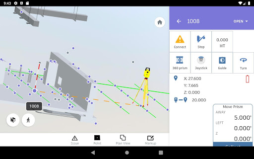
Robotic Total Station Controller
◆ Seamless connection to total station hardware with automated direct Bluetooth communications
◆ Control the total station remotely utilizing guide and point-turn functionality
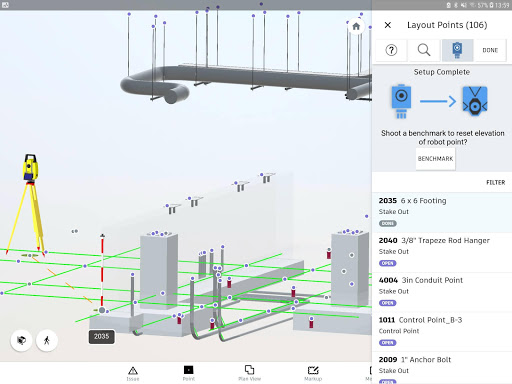
◆ Step-by-step, guided total station set-up routines for Known Point and Resection including help guides for each step
User Interface and Navigation
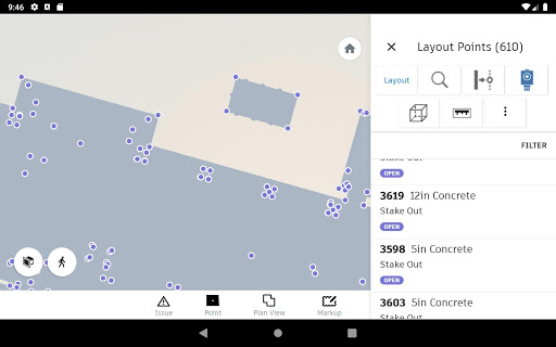
◆ Select levels and filter both points and the model, then navigate directly to that location in 3D model view
◆ Automatically sorted by nearest point routine as the user walks the jobsite to improve efficiency
◆ Optimized views to see total station, prism, selected point and auto-zoom 2D & 3D viewing modes when nearing a point
◆ Real-time model navigation for conducting layout, QA/QC and as-builting on the job site.
◆ Line Offsets Feature to create a line between two points and stake along and offset from that line
◆ 'Box Around Point' tool to create a custom section box around a point in both 2D/3D
______________________
Requirements: Compatible with Android Web GL 5.0 or later.
Accolades:
• ForConstructionPros.com – App of the Week, February 17, 2015
Downloads
1.2.3.4.5.6.7.8.9.0
LATEST
02/20/2023
Download
50.83 MB
1.2.3.4.5.6.7.8.9.0
LATEST02/20/2023
Supported Architectures
MD5 Checksum
a678a084205b3b2da6ef2aee31b5df78
Minimum SDK Version
28
Version Code
1000203321
Upload Date
Feb 20, 2023, 5:11:28 AM
1.2.3.4.5.6.7.8.9.0
01/23/2023
Download
50.37 MB
1.2.3.4.5.6.7.8.9.0
01/23/2023
Supported Architectures
MD5 Checksum
20e96a1179ba2e69c8b86a1614f22364
Minimum SDK Version
28
Version Code
1000203312
Upload Date
Jan 23, 2023, 5:11:15 AM
1.2.3.4.5.6.7.8.9.0
11/14/2021
Download
26.86 MB
1.2.3.4.5.6.7.8.9.0
11/14/2021
Supported Architectures
MD5 Checksum
08aa4b3a1e6ab81ee8b5e4cb818465a8
Minimum SDK Version
21
Version Code
1000203211
Upload Date
Nov 14, 2021, 8:30:58 PM
Similar Apps
Event's Security Committee
5.0
everyone
Habitodo: lists, habits & todo
5.0
everyone
Wader Pilot Logbook
5.0
teen
Calendar - Easy Planner
5.0
everyone
AI Chatbot: Assistant Chat Bot
5.0
everyone
Simple Tasks & Notes
5.0
everyone
Epi Info™ Vector Surveillance
5.0
everyone
Zoho BugTracker
5.0
everyone
Vimar Products
5.0
everyone
ADERP | ADGov
5.0
everyone